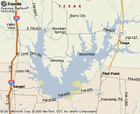
Lake
Ray Roberts
One of Texas' newest lakes with a surface area of 29,350
acres. Dam is at river mile 60 on the Elm Fork of the
Trinity River midway between the towns of Sanger and Pilot
Point, approximately 12 miles northeast of Denton off
I-35. Owned by cities of Dallas and Denton. Popular destination
for swimming, boating, and fishing. Isle du Bois State
Park encompasses more than 1,300 acres for recreational
use, including a 12-mile multi-use trail for hiking, bicycling,
and equestrian use (your horse). Accessible from Gainesville,
Sanger, Aubrey, Pilot Point, and Tioga, as well as the
Dallas/Fort Worth Metroplex Cities.
Ray
Roberts Lake State Park Isle Du Bois Unit
From city: US 377 S .8 mi; FM 455 W 3 mi. 11 miles of
shoreline on Lake Ray Roberts. Wheeled camper sites w/elec
& water, 115; 55 walk-in campsites w/water; 14 campsites
approved for equestrian use w/water; day-use group picnic
area by rsvn. Dump sta, fl toilets, showers. Swim-lake;
playgrounds, boat ramps, fishing pier, fish cleaning station,
bathhouse. 4.5-mile hike/bike trail to Jordan Satellite
Park. 10-mile multiuse greenbelt corridor between Ray
Roberts Lake & Lake Lewisville. 940/686-2148
Ray
Roberts Lake State Park Johnson Branch Unit
From city: I-35 S 4 mi; E 7 mi on FM 3002 (Lone Oak Rd,
Exit 483). On north shore of Ray Roberts Lake. Wheeled
camper sites w/elec & water 104; walk-in campsites
w/water 50; primitive sites 33; 2 day-use picnic pavilions
by rsvn. Dump sta, fl and chem toilets, showers. Swim-beach;
fish, fish cleaning shelter, boat ramp, playground and
hike and bike trails.